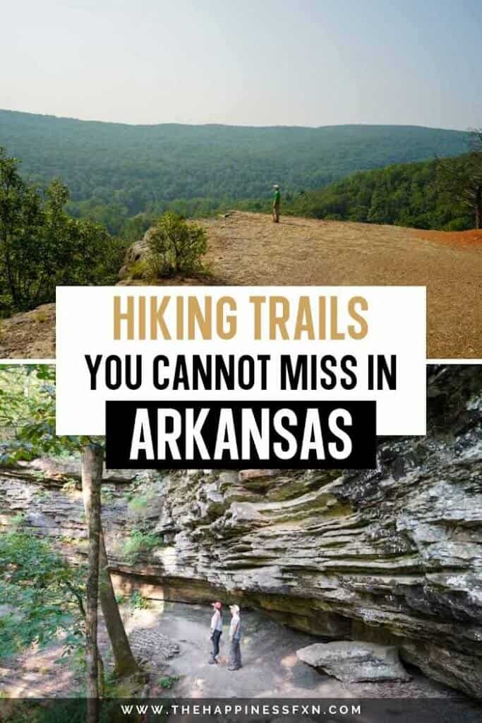
12 Incredible Hiking Trails in Arkansas You Cannot Miss

This guide shares our favorite hiking trails in Arkansas, including their locations and details about each hike. It focuses on day hikes in the Ozarks and Ouachitas.
Arkansas is home to some of the most beautiful hiking trails in the U.S. and if you’re not from the area, you would probably never realize how gorgeous the state is.
You can find various terrains and landscapes, including pine-oak forests, mountain ranges, and lush valleys. The highest point in Arkansas is Signal Hill at Mount Magazine, at an elevation of 2,753 feet.
There are various types of trails to enjoy, including those with waterfalls or caves and challenging treks along rocky terrain leading to majestic bluff overlooks.
A Hiker’s Guide To Arkansas

We love hiking in Arkansas and have been excited to walk enough trails to put together a guide for our readers. Since we live in northeast Oklahoma, it has taken a few weekend trips to gather the best trails for you.
One of the most exciting things about trekking through Arkansas is that you never know what to expect.
The forests are dense and lush, so sometimes you can be hiking along a narrow trail with the forest brushing against you. Other times, the trail is more open. Or the next thing you know, there is a clearing, and you’re on top of a mountain overlooking a vast Jurassic Park-like valley.
Whitaker Point Trail (a.k.a. Hawksbill Crag)

- Location: Ozark National Forest near Pettigrew, AR
- Difficulty: Moderate
- Distance: 2.9 miles out and back
- Parking: Yes, small parking area near the trailhead.
- Dog friendly: Yes, leash-requirement
- Cost: Free
- Restrooms: None
- Cell Phone Reception: Hit and Miss
The hike starts at the Whitaker Point Trailhead off Country Road 5. There is a small parking area, and once that fills up, you can park along the county road.
You’ll hike downhill towards the end of the trail, where the crag is hidden in the forest. The trail slowly switch-backs from the parking lot along the ridge through the trees. Depending on the time of year, there is also a small waterfall along the way.
The hike to Whitaker Point is one of our favorite hikes in northwest Arkansas, especially in the fall. Take time to enjoy the views and one of the best hikes in the Ozarks.
Check out our guide to hiking the Whitaker Point Trail.
North Rim Trail

- Location: Mount Magazine State Park near Paris, AR
- Difficulty: Moderate-Strenuous
- Distance: 2.7 miles (one-way) from the Visitor Center to the Cove Lake Trail parking lot north of the campground or a 4.2-mile loop connecting to the Mossback Ridge Trail.
- Parking: Yes, multiple trailhead parking lot options (east or west ends)
- Dog friendly: Yes, leash-requirement
- Cost: Free
- Restrooms: Yes, at the Visitor Center or campground area
- Cell Phone Reception: Yes, enough to use AllTrails online
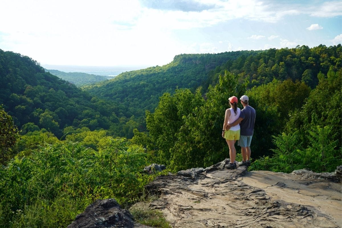
The North Rim is located in Mount Magazine State Park in the Ouachita Mountains. As we were saying earlier, Mount Magazine has the tallest point in Arkansas — Signal Hill (more on Signal Hill below). The north rim of the park has awesome views.
There are multiple trailheads to complete the North Rim Trail. You can start at the east end near the Visitor Center, which we did, or start on the west end north of the campground. You can also hike it as a loop.
Walk along the north rim of Mount Magazine through the cedars and oaks. There are three small creek crossings. Be sure to take the small lookout trail to Dill Point and some of the other bluff openings to see views of the Arkansas River Valley. On a clear day, you can see the Ozarks off in the distance.
Take precautions while enjoying the steep bluffs that jet out from the forest. The trail is pretty rugged and definitely remote.
Dill Point overlook is not marked, so bring a map to ensure you don’t miss it. You can hike this trail year-round, but be aware that it can be overgrown.
Plan your weekend getaway to Mount Magazine State Park with our guide.
Signal Hill Trail

- Location: Mount Magazine State Park near Paris, AR
- Difficulty: Moderate
- Distance: 1.8 miles
- Parking: Yes, near the campground entrance or at the Lodge.
- Dog friendly: Yes, leash-requirement
- Cost: Free
- Restrooms: Yes, at the Visitor Center, campground, and Lodge
- Cell Phone Reception: Yes, enough to use AllTrails online
Signal Hill is located within Mount Magazine State Park. It is the tallest point in Arkansas at an elevation of 2,753 feet. This trail makes the list of the best hiking trails in Arkansas because you have to hike to the tallest point in the state.
When hiking Signal Hill, there are three different trailheads to choose from. The trail is well-marked from the road.
Signal Hill is considered an easy to moderate difficult hiking trail.
While visiting Mount Magazine, be sure to catch a sunset at the Cameron Bluff Overlook.
Devil’s Den Trail

- Location: Devil’s Den State Park near West Fork, AR
- Difficulty: Moderate
- Distance: 1.2 miles
- Parking: Yes, at the trailhead
- Dog friendly: Yes, leash-requirement
- Cost: Free
- Restrooms: Yes, at the Visitor Center or campgrounds
- Cell Phone Reception: None
Hiking in the Ozarks is always an unforgettable experience (in my opinion). On this scenic hike, you walk past caves and a waterfall.
The trail is short and moderately challenging. There are neat rock formations and caves tucked within the forest.
The hardest part of this hike is keeping your eyes off the beautiful scenery around you and being careful as you step along the stone pathways.
All of the caves are closed to protect the local bat population from White-Nose Syndrome, but you can still take pictures of the caves from their openings. I think it’s cool that you can feel the caves “breathing” when you get close enough.
Devil’s Den State Park is an excellent place for hikers and campers.
Plan a weekend hiking and camping with our guide to Devil’s Den State Park.
Yellow Rock Trail

- Location: Devil’s Den State Park near West Fork, AR
- Difficulty: Moderate
- Distance: 3.1 miles
- Parking: Yes. There are two parking areas. One is at the CCC Overlook (upper trailhead), and the other parking area is near Camp Area A (lower trailhead).
- Dog friendly: Yes, leash-requirement
- Cost: Free
- Restrooms: Yes, at the Visitor Center or campgrounds
- Cell Phone Reception: Hit and Miss
Yellow Rock Trail is our favorite hike at Devil’s Den State Park.
The upper trail meanders through the forest and along the ridge line. Then, you pop out of the trees and are treated to an epic view of the Yellow Rock Bluff and Lee Creek Valley.
Once you reach Yellow Rock Bluff, enjoy the lookout, take photos, and breathe in the smell of the Ozarks.
The sound of the forest here in the summer is impressive (because of the bugs and frogs). I’ll never forget how the forest sounds here at night when camping.
Seven Hollows Trail
- Location: Petit Jean State Park near Morrilton, AR
- Difficulty: Moderately difficult
- Distance: 4 ½ miles – trail loops
- Parking: Yes, designated parking area
- Dog friendly: Yes, leash-requirement
- Cost: Free
- Restrooms: Yes, at the Visitor Center or campgrounds
- Cell Phone Reception: Hit and miss throughout the park – none while hiking
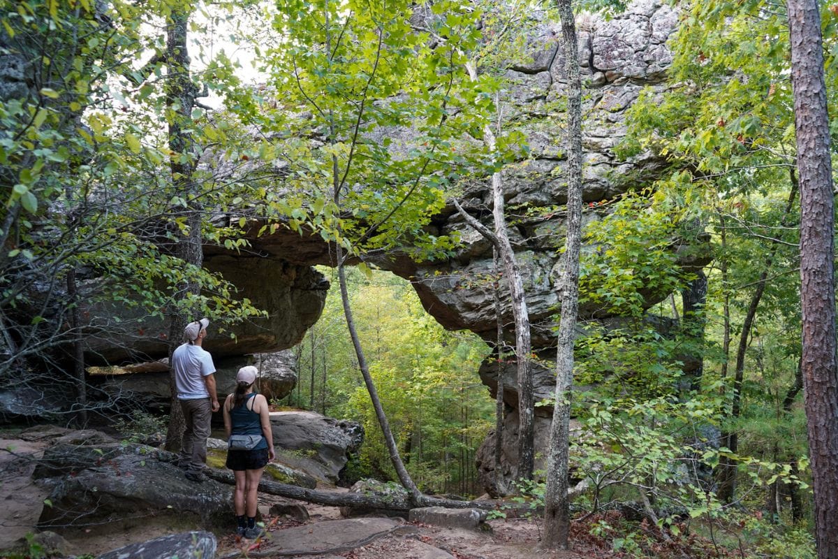
Hike the Seven Hollows Trail at Petit Jean State Park to an incredible natural bridge. The trail is well marked with signs every ½ mile or so, highlighting unique places, such as ‘The Grotto’ and ‘Natural Bridge.’
The path is well-maintained and marked and meanders through the forest with rock formations.
Be sure to take plenty of water and snacks because it can get hot and humid if hiking during the summer months. Most of the trail is shaded nicely by the tree canopy.
A local who hikes here often told us to watch for snakes, so we’ll pass that on for your safety, too.
Plan your next hiking and camping trip to Petit Jean using our guide.
Rock House Cave
- Location: Petit Jean State Park near Morrilton, AR
- Difficulty: Easy
- Distance: ¼ mile – gravel trail
- Parking: Yes, plenty at the trailhead
- Dog friendly: Yes, leash-requirement
- Cost: Free
- Restrooms: Yes, at the Visitor Center or campgrounds
- Cell Phone Reception: Some near Visitor Center and campgrounds – hit and miss throughout the area
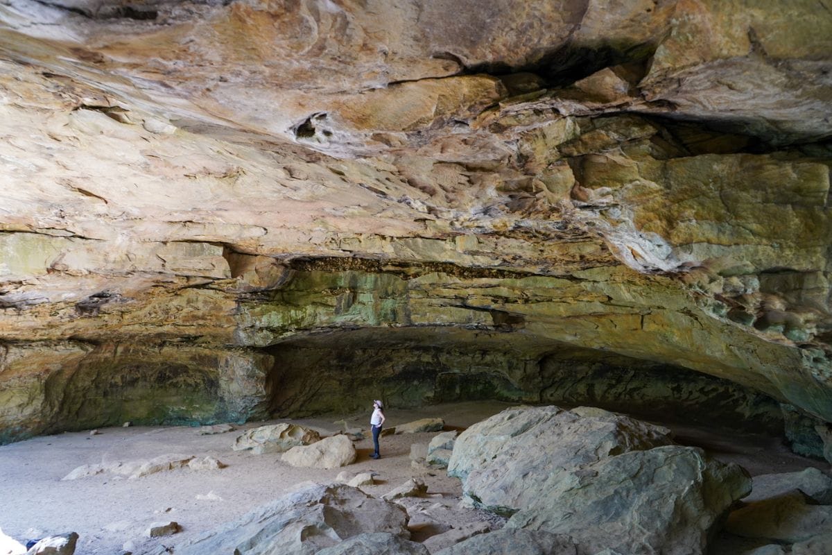
One of our favorite things to do is find hikes in unique terrain, and Rock House Cave at Petit Jean State Park does not disappoint.
Though the hike to the Rock House Cave is a short quarter mile from the parking lot, this protected archeological site makes the list because it is so neat. It is a tucked-away gem and easy to access, so anyone can see it.
There are pictographs on the ceilings.
Planning tip: Exploring Rock House Cave and Bear Cave Trail (below) on the same day pairs nicely. Both trailheads are within close driving distance of each other at Petit Jean State Park.
Bear Cave Trail

- Location: Petit Jean State Park near Morrilton, AR
- Difficulty: Easy
- Distance: ¼ mile – gravel trail
- Parking: Yes, plenty at the trailhead
- Dog friendly: Yes, leash-requirement
- Cost: Free
- Restrooms: Yes, at the Visitor Center or campgrounds
- Cell Phone Reception: Hit and Miss
Bear Cave Trail at Petit Jean State Park is neat. It’s a short hike—only a quarter mile—but the best part is scrambling in the rocks and taking pictures.
Centerpoint to Big Bluff (Goat Trail)

- Location: Buffalo National River near Ponca, AR
- Difficulty: Easy to Moderate
- Distance: 6 miles round trip (O&B) hike
- Parking: Yes, plenty at the Ponca Centerpoint Trailhead
- Dog friendly: No, within Buffalo National River National Park
- Cost: Free
- Restrooms: None
- Cell Phone Reception: Hit and miss
The Centerpoint to Big Bluff (Goat Trail) is located near Ponca, Arkansas, within the Buffalo National River National Park boundaries. It is a 6-mile hike (out and back) with roughly 1,000 feet of total elevation gain to one of the tallest bluffs in the area.
Known for its “million-dollar views” of the Buffalo River Valley and narrow trail along Big Bluff (a.k.a. the Goat Trail), you won’t regret your decision to bring your camera (and your sense of adventure) to trek this hike.
Pablo and I were blown away when we got to the lookout point.
Plan your hike using our Centerpoint to Big Bluff trail guide.
Lost Valley Trail in Buffalo National River

- Location: Buffalo National River near Ponca, AR
- Difficulty: Easy to Moderate
- Distance: 2.3 miles round trip (O&B) hike
- Parking: Yes, plenty at the trailhead
- Dog friendly: No, within Buffalo National River National Park
- Cost: Free
- Restrooms: Yes, at the trailhead managed by the National Park Service
- Cell Phone Reception: None
If your idea of a great trail is easy, with lots of beautiful scenery and rocks, then check out the Lost Valley Trail in Buffalo National River. It is one of the most popular hikes in Buffalo National River.
The first mile of the trail follows an easy path into a box canyon, leading hikers to explore two waterfalls and an enormous 200-foot bluff shelter. Eden Falls is a 53-foot waterfall.
Plan your Lost Valley hike using our trail guide.
Hemmed in Hollow Trail in Buffalo National River
- Location: Buffalo National River near Compton, AR
- Difficulty: Difficult
- Distance: 5.7 miles out and back to the waterfall, but add another 1.4 miles if you go to the river.
- Parking: Yes, plenty at the Compton Trailhead
- Dog friendly: No, within Buffalo National River National Park
- Cost: Free
- Restrooms: None
- Cell Phone Reception: Only at the Compton Trailhead. Once you go into the river valley, there is no cell reception.
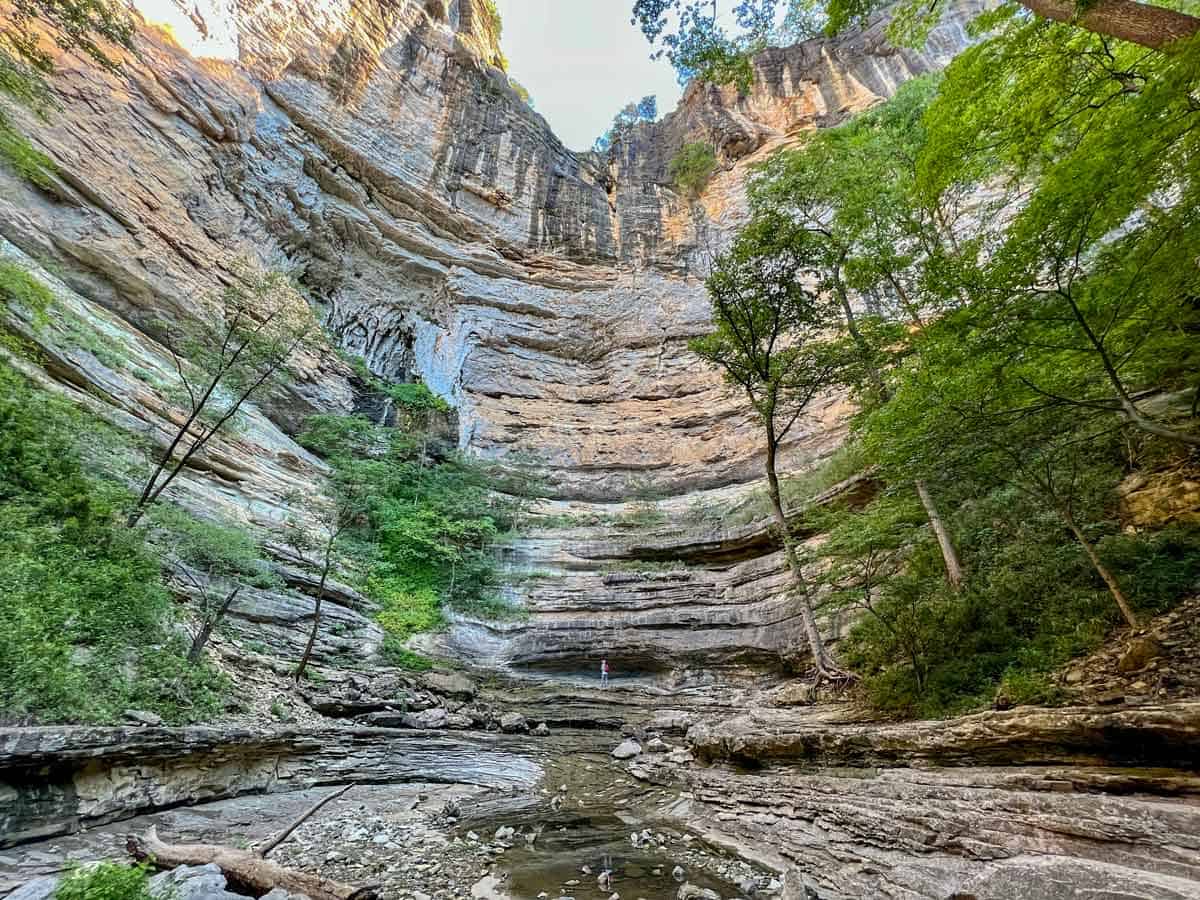
Hemmed in Hollow Falls is touted as one of the tallest waterfalls in mid-America. It truly is a sight to see cascading over 200 feet from the bluffs. The waterfall is seriously so enormous it hurts to look up.
The Hemmed in Hollow Trail from the Compton Trailhead is considered difficult due to the elevation changes. Going down is easy, but climbing back up is the equivalent of hiking to the top of the Empire State Building.
You can also access the falls by floating on the Buffalo National River if you don’t want to hike.
This is one of the most incredible hikes we have done in a while. To cool off, be sure to hike to the river and swim.
It takes about 4 ½ hours to hike from the Compton Trailhead to the falls and river and back. Take your time. Bring lots of water and snacks.
Plan your hike to Hemmed in Hollow using our helpful trail guide.
Pedestal Rocks and Kings Bluff Scenic Loop

- Location: Near Pelsor, AR
- Difficulty: Moderate
- Distance: 4.6 miles – loop hike
- Parking: Yes, plenty at the trailhead
- Dog friendly: Yes, within the Ozark National Forest
- Cost: Free
- Restrooms: Yes, at the trailhead
- Cell Phone Reception: Some
If you love exploring rock formations, then add the Pedestal Rocks and Kings Bluff Scenic Loop to your Arkansas hiking list.
Start the loop by trekking Kings Bluff. There are beautiful views of the mountains and bluffs. Next, wander towards the Pedestal Rocks Scenic Area, where you can explore the caves, arches, and other rock formations.
The trails are easy to follow, but watch where you step. There are steep ledges and cliffs without railings.
Read our Pedestal Rocks and Kings Bluff trail guide to help you plan your trip.
Best Time of Year to Hike in Arkansas
Spring: If you’re chasing waterfalls, spring is the best time of year to hike. The weather is also cooler, and things are just starting to green up.
Summer: The key to hiking in the summer when it is hot and humid is to start walking early in the day and be done before noon. All of these hikes are in the trees, and there is shade for the most part. Be sure to apply tick spray.
Fall: This is one of the best times of the year to hike in Arkansas because the sides of the mountains are bursting with beautiful colors.
Winter: We love hiking in Arkansas during the winter. I like that the trees are bare, so you can see views you don’t normally see during the greener months. I also like hiking in my cozy layers.
Have fun out there.
❤️ Ashlee & Pablo
More Arkansas Guides:
If you love Arkansas as much as we do, check out these guides to plan your next adventure:
Save for Later!
Pin this hiking guide on Pinterest to plan your hiking trip later.


Please practice Leave No Trace when exploring the outdoors.
Follow The Happiness Function on Twitter, Instagram, Facebook, TikTok and YouTube.
You have covered the hikes in Arkansas so well with detailed info. I love my Oboz hiking boots as well and highly recommend them.
Hi there! Thanks for reading! Sweet on your Oboz! We agree they make the best hiking shoes and boots. We recently got a new pair of the low tops and love them just at much at the mid-leather.
I have never been to Arkansas. This place looks awesome. I would love to do those hikes especially Devil’s Den Trail with the unique rock formations towering above you. Great capture! I am adding this to my bucket list. 🙂
Hi Jan! Arkansas has really neat places to explore. You’ll love visiting.
The USA has some of the best national parks I’ve seen. I would love to explore some of them someday. Your suggestions for the hiking trails in Arkansas is what I would definitely go for if I ever end up in this part of the world.
Hi Carmina! We agree – the USA has incredible National and State Parks to explore. You would have an amazing time. Thanks for reading.
Wow, Arkansas looks like such a beautiful, mesmerising place, I would love to visit someday!!! It seems like there’s plenty to keep a traveller busy 🙂
Hi Amy – there are so many incredible hiking trails in Arkansas. We hope you can visit someday!
I’m loving the views from Yellow Rock Bluff, I could sit there for hours. I bet it gets hot there though.
Hi Aimee – the views from Yellow Rock Bluff are world-class. You would love them. It did get hot in the sun on the bluff but the rest of the trail is shaded.